
|
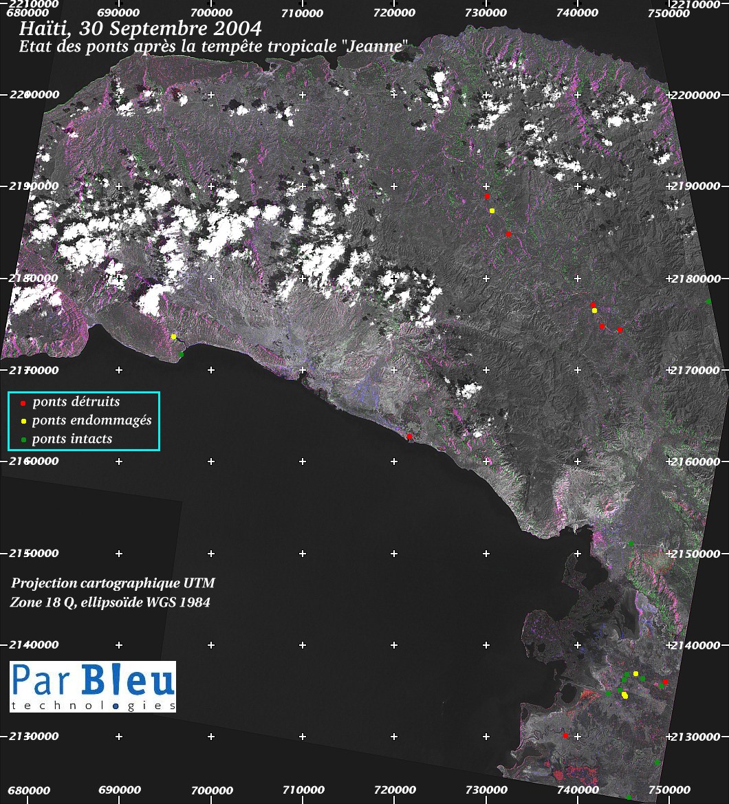
Bridges status after the tropical storm "Jeanne" in the départements of "Nord-Est" and "Artibonite" has been assessed by analysis of :
The table below summarizes the results of this analysis. A location map (in UTM cartographic projection) for the bridges, at a spatial resolution of 75 meters x 75 meters is provided at the end of the present page. |
|---|
| Geographic Location of Bridge | Bridge Status | |
| UTM Northing | UTM Easting | |
| "Les Trois Rivières" | ||
| 2177288 | 754480 | intact |
| 2174363 | 744655 | destroyed |
| 2176793 | 741805 | damaged |
| 2175548 | 742690 | destroyed |
| 2177153 | 741745 | destroyed |
| 2184818 | 732520 | destroyed |
| 2187368 | 730645 | damaged |
| 2188928 | 730135 | destroyed |
| "Département Nord-Est": South Coast | ||
| 2171693 | 696820 | intact |
| 2173598 | 696010 | damaged |
| 2162723 | 721630 | destroyed |
| Around Gonaives | ||
| 2151008 | 745870 | intact |
| Rivers around Villard | ||
| 2136008 | 749620 | destroyed |
| 2135888 | 749380 | intact |
| 2136383 | 747055 | intact |
| 2136803 | 746410 | damaged |
| 2136833 | 745375 | intact |
| 2136218 | 745165 | intact |
| 2135033 | 744760 | intact |
| 2134598 | 743350 | intact |
| Artibonite River | ||
| 2130128 | 738655 | destroyed |
| 2126993 | 745195 | damaged |
| 2127098 | 745120 | damaged |
| 2123408 | 745570 | intact |
| 2127143 | 748720 | intact |
Location map :
Produced by PARBLEU TECHNOLOGIES Inc. under mandate of the CANADIAN SPACE AGENCY.
(Standing Offer for Disaster Management Information Products and Services; PWGSC File Number 9F028-014927/008/ST)
Procurement of the original RADARSAT-1 SAR data: Canadian Space Agency and Radarsat International Inc.
Procurement of the LANDSAT-7 ETM+ image: Courtesy of the University of Maryland, Global Land Cover Facility
Copyright (C) PARBLEU Technologies Inc., October 2004