Polarimetric SAR Images

- This example illustrates the performances of a fully polarimetric speckle
filter: the Wishart-Gamma Maximum A Posteriori (MAP) adaptive speckle filter
for polarimetric SAR images
(A. Lopes, S. Goze, E. Nezry: "Polarimetric
Speckle Filters for SAR Data", Proceedings of IGARSS'92, Vol.1, pp.80-82,
May 1992).
In this version, detectors for edges, linear structures and
point targets are associated to the polarimetric filtering process
(E. Nezry,
A. Lopes, R. Touzi: "Detection of structural and textural features for SAR images
filtering", Proceedings of IGARSS'91, Vol.4, pp.2169-2172, June 1991).
(Original data © JPL 1989; Processed image © Privateers N.V. 1996)
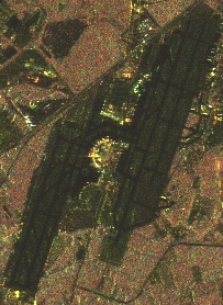
The upper image is a 4-looks JPL-AIRSAR high resolution airborne polarimetric
SAR image (Jet Propulsion Laboratory, Pasadena, CA, USA), P-band, polarizations
HH (green), HV (red) and VV (blue). The imaged scene is the Landes pine
forest in southwest France.
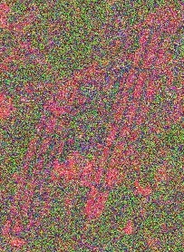
The bottom image is the filtered one. Speckle
is efficiently removed on all three HH, HV, and VV channels, without loss
in useful spatial resolution of the radar sensor.
The textural properties
of the imaged scene are well restored on all three polarimetric channels,
as it is visible within the forest stands which are much better identified
on the filtered image.
To cope with the specific cases in which the theoretical assumptions of the
Wishart-Gamma MAP filter are no longer reliable (very textured scene, scene located
on strong relief), PRIVATEERS NV has developed a new fully polarimetric adaptive
speckle filter: the Wishart/Distribution-entropy MAP filter
(E. Nezry and
F. Yakam Simen, 1999: "New distribution-entropy Maximum A Posteriori speckle filters for
detected, complex, and polarimetric SAR data", Proceedings of IGARSS'99, Vol.3, July 1999).
With this new polarimetric filter, we are presently able to restore optimally the
radar reflectivity and the textural properties of all possible imaged scenes
(E.
Nezry and F. Yakam Simen, 1999: "On the preservation of polarimetric signatures and
polarimetric texture signatures by fully polarimetric MAP filters", Proceedings of
IGARSS'99, Vol.3, July 1999).
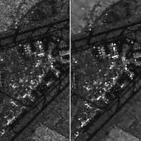
Application of the Wishart/Distribution-Entropy MAP polarimetric filter to spaceborne ALOS PALSAR polarimetric radar data is illustrated below:
Original unfiltered data (left) © JAXA 2006; Processed image (Wishart/Distribution-Entropy MAP; right) © Privateers/ParBleu 2006
HH, VV and HH polarizations are represented in red, green, and blue.
HH-VV, HH-HV and VV-HV degrees of coherence are represented in red, green, and blue.
(unfiltered data: left; Wishart/Distribution-Entropy MAP filtered; right)
- It is noteworthy that, since these filters are fully polarimetric, all
useful polarimetric features, such as phase differences and degrees
of coherence between polarization configurations, are also restored
with the same efficiency as it is the case of the radiometry.
- This speckle filtering process is particularly adapted to the treatment
of spaceborne polarimetric SAR images.
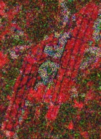
Retrieval of Forest Biomass and Timber Volume
- The black areas in the above polarimetric images correspond to recent
clearcuts.
In this color representation, the evolution from black to grey,
brown, green, violet and blue corresponds to an increase:
- in forest biomass from 0 to 120 tons/ha
(A. Beaudoin,
T. Le Toan, S. Goze, E. Nezry, A. Lopes, E. Mougin, C.C. Hsu, H.C.
Han, J.A. Kong, R.T. Shin: "Retrieval of forest biomass from SAR data",
International Journal of Remote Sensing, Vol.15, n°14, pp.2777-2796,
Sept. 1994),
- and in forest age from 0 to 45 years
(E. Nezry, A. Lopes,
D. Ducrot-Gambart: "Supervised radiometric and textural segmentation
of SAR images", Proceedings of IGARSS'93, Vol.3, pp.1426-1428, Aug.
1993).
- Other methods for forest biomass retrieval, developed at PRIVATEERS NV,
using the complementarity between spaceborne SAR and optical sensors, and very
satisfactory results have been obtained
(G. Kattenborn, E. Nezry:
"Analysis of an ERS SAR time series and optical satellite data for forestry
applications in temperate zones", Intnl. Archives of Photogrammetry and Remote
Sensing, Vol.31, Part B7, pp.331-339, July 1996).
 Timber volume estimation, with less than 15% error in the range 0-260 mł/ha
has been achieved by PRIVATEERS NV in commercial operations, using:
Timber volume estimation, with less than 15% error in the range 0-260 mł/ha
has been achieved by PRIVATEERS NV in commercial operations, using:
- Spaceborne Radar (SAR) and Optical data
- (E. Nezry and L. Demargne, 1998:
"Using
SPOT and radar data to inventory forests in Sarawak, Malaysia",
Spot Magazine, n°29, pp.28-31, July 1998).
- (E. Nezry, F. Yakam Simen and I. Supit: "Estimation of forest
biomass or timber volume using JERS-1 and/or ERS SAR's: A comparative application to
the Honduran rainforest", Proceedings of IGARSS'2000, Vol.1, July 2000).
- C-band SAR and L-band SAR images
(E. Nezry, J. Schotanus Sakiman, Soethomo
and F. Yakam Simen: "Assessment of JERS-1 data to implement a fire prevention project
in Indonesia", pilot project J-2RI-008, report to NASDA, May 2002).
|

 A Speckle Filtering Module for Radar (SAR) images, including all the newest adaptive speckle filtering algorithms developed by