Techniques and Services
Synthetic Aperture Radar (SAR) Image Processing Techniques
SAR Applications for Operational Remote Sensing
Optical / Near Infrared Remote Sensing
Medical Imagery
- Nuclear Magnetic Resonance (NMR) Image Processing
- Tomography Data Processing
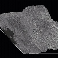
Radar (SAR) Data Pre-Processing
- SAR Image Full Radiometric Calibration
(ERS, ENVISAT, RADARSAT, JERS-1, ALOS, X-SAR, TerraSAR-X image products).
Application of the following radiometric corrections, whenever needed:
- Antenna Pattern correction
- Range Spreading Loss correction
- Correction of Ground Range Sampling effects
- Replica Pulse Power correction
- Correction of Analog to Digital Loss
- Processor Noise Power correction
- Application of the Calibration Constant
- Output Formats: TIFF, GEOTIFF, floating, integer 16-bit or integer 8-bit per pixel
- Restoration of correct image orientation
(ERS, ENVISAT, RADARSAT, JERS-1, ALOS, X-SAR,, TerraSAR-X image products).
- Resampling to the desired pixel size and resolution (for the production
of wide scale mosaics and maps):
(ERS, ENVISAT, RADARSAT, JERS-1, ALOS, X-SAR, TerraSAR-X image products)
- By linear Resampling
- By Correlated Block Averaging / Resampling
- By Adaptive Filtering / Resampling
- Slant Range to Ground Range Resampling, when applicable
- Extraction of system and orbit parameters
(ERS, RADARSAT, ENVISAT, JERS-1, ALOS, X-SAR, TerraSAR-X image products)
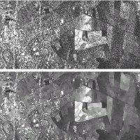
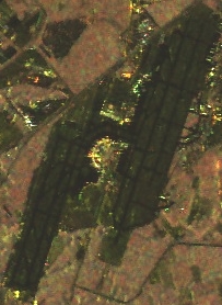
Adaptive Speckle Filtering in Radar (SAR) Images
- Adaptive Speckle Filtering of Detected (Amplitude or Intensity) single channel SAR images
 (ERS, ENVISAT, RADARSAT, JERS-1, ALOS, X-SAR, TerraSAR-X, Airborne SAR image products)
A great choice of adaptive speckle filters is available (non-exhaustive list):
- Lee Filter
- Kuan et al. Filter
- Frost et al. Filter
- Ping Fan Yan & Chen Filter
- Enhanced Lee Filter
- Enhanced Kuan et al. Filter
- Enhanced Frost et al. Filter
- Structure retaining Lee Filter
- Structure retaining Gamma-Gaussian MAP Filter
- Structure retaining Gamma-Beta MAP Filter
- Structure retaining Gamma-Gamma MAP Filter
- Structure retaining Gamma-Gamma MAP Filter, using 2nd order statistics
- Structure retaining Gamma-Distribution_Entropy MAP Filter
- Structure retaining Gamma-Distribution Entropy MAP Filter, using 2nd order statistics
- Structure retaining Gamma-Gamma APM Filter
- Structure retaining Gamma-Gamma APM Filter, using 2nd order statistics
- Adaptive Speckle Filtering of Detected (Amplitude or Intensity) multi-channel SAR images:
(ERS, ENVISAT, RADARSAT, JERS-1, ALOS, X-SAR, TerraSAR-X, Airborne SAR image products, time-series or combination of SAR sensors)
- Structure retaining Lee et al. (multi-channel) Whitening Filter
- Structure retaining Lee et al. (multi-channel) Whitening Filter, using 2nd order statistics
- Structure retaining (multi-channel) Optimal Summation by Minimization of the Variance
- Structure retaining Optimal Summation by Minimization of the Variance, using 2nd order statistics
- Structure retaining MMSE (multi-channel) Optimal Summation
- Structure retaining MMSE (multi-channel) Optimal Summation, using 2nd order statistics
- Structure retaining Gamma-Gaussian MAP (multi-channel) Filter
- Structure retaining Gamma-Gaussian MAP (multi-channel) Filter, using 2nd order statistics
- Structure retaining Gaussian-Gaussian MAP (multi-channel) Filter
- Structure retaining Gaussian-Gaussian MAP (multi-channel) Filter, using 2nd order statistics
- Structure retaining Gaussian-Distribution_Entropy MAP (multi-channel) Filter
- Structure retaining Gaussian-Distribution_Entropy MAP (multi-channel) Filter, using 2nd order statistics
- Adaptive Speckle Filtering of Single-Look Complex (SLC) SAR images,
Complex Separate Multi-Look SAR images, or Multi-Channel Complex SAR Images (eg. interferometry):
(ERS, ENVISAT, RADARSAT, JERS-1, ALOS, X-SAR, SIR-C, and Airborne SAR image products)
- Structure retaining Speckle Whitening (complex) Filter
- Structure retaining Speckle Whitening (complex) Filter, using 2nd order statistics
- Structure retaining Gaussian-Gamma MAP (complex) Filter
- Structure retaining Gaussian-Gamma MAP (complex) Filter, using 2nd order statistics
- Structure retaining Gaussian-Distribution_Entropy MAP (complex) Filter for Single Look Complex SAR images
- Structure retaining Gaussian-Distribution_Entropy MAP (complex) Filter for separate multi-look Complex SAR images,
or Multi-Channel Complex SAR Images (eg. interferometry)
- Adaptive Speckle Filtering of Polarimetric SAR images:
(JPL-AIRSAR, SIR-C, ALOS, RADARSAT-2, and other polarimetric SAR data products)
- Structure retaining Lee et al. LMMSE Filter
- Structure retaining Wishart-Gamma MAP (fully polarimetric) Filter
- Structure retaining Wishart-Distribution_Entropy MAP (fully polarimetric) Filter
- Adaptive Speckle Filtering of Interferometric SAR (InSAR) Data:
(Interferometric Pairs ERS, ENVISAT, JERS-1, ALOS, RADARSAT, X-SAR, etc.)
- Restoration of the Degree of Coherence by adaptive speckle filtering (PRIVATEERS InSAR Filter)
- Restoration of the Phase Difference (SAR Interferogram) by adaptive speckle filtering (PRIVATEERS InSAR Filter)
SAR and/or Optical Data Analysis and Exploitation: Some of our Specialities
- Enhancement of the Spatial Resolution of your Remote Sensing Images (Super-Resolution)
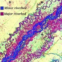
- Production
of Soil Moisture and Soil Roughness maps
(Data Fusion: ERS/ENVISAT and RADARSAT, ENVISAT/ALOS, RADARSAT/ALOS, or bi-incidence SAR)
- Production
of Woody Biomass maps and/or Timber Volume maps
(Optical and SAR, or L- and C-Band SAR's Data Fusion)
- Early
Season Crop Acreage estimations and Identification of Major Crops using SAR images
(ERS, ENVISAT, JERS-1, ALOS, or RADARSAT)
- Detection/Identification of Man-Made Targets in SAR images
(ERS, ENVISAT, JERS-1, ALOS, RADARSAT, TerraSAR-X)
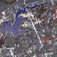
- Detection of Tracks under Tropical Forest:
- in SAR images (ERS, ENVISAT, JERS-1, ALOS, RADARSAT, TerraSAR-X), or
- in Optical images (IRS, LANDSAT-ETM+, TERRA-ASTER, SPOT, etc.)
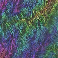
- Production of Digital Elevation Models
(DEM) from stereo pairs of SAR and/or Optical images:
- RADARSAT multi-incidence, or
- ENVISAT multi-incidence, or
- ALOS multi-incidence, or
- ERS/ENVISAT and RADARSAT, or
- JERS-1/ALOS and RADARSAT, or
- ERS/ENVISAT and JERS-1/ALOS, or
- Spaceborne SAR (ERS, ENVISAT, JERS-1, ALOS, or RADARSAT)
and Optical sensor (SPOT, IRS, LANDSAT-TM/ETM+, TERRA-ASTER), or
- SPOT multi-incidence, or
- JERS-1 OPS multi-incidence, or
- TERRA-ASTER multi-incidence, or
- Combination of Optical sensors.
- Radiometric and Geometric Corrections of Terrain Induced Effects
in SAR and Optical Images, using a DEM
- Production of Ortho-rectified Space-Maps at high
spatial resolution, in geographic projection, using
- SAR sensors: ERS, ENVISAT, JERS-1, ALOS, RADARSAT, X-SAR, TerraSAR-X, or
- Optical sensors: IRS, SPOT, LANDSAT, TERRA-ASTER, TERRA/AQUA-MODIS, MOS, RESURS, IKONOS, ORBVIEW, etc.
Software
 A Speckle Filtering Module for Radar (SAR) images, including all the newest adaptive speckle filtering algorithms developed by
PRIVATEERS
NV is available since 2004 within
SARscape,
a most professional image processing software package.
A Speckle Filtering Module for Radar (SAR) images, including all the newest adaptive speckle filtering algorithms developed by
PRIVATEERS
NV is available since 2004 within
SARscape,
a most professional image processing software package.
SARscape is fully compatible with the geomatics and GIS (Geographic Information System) software ®IDL-ENVI (Research Systems Inc.) and ®ArcView (ESRI Inc.).
SARscape supports Windows 98/NT/2000/XP and Linux 2.6 operating systems.
The filtering module provides different specific algorithms to process :
- Single- or multi-look, single channel detected (in amplitude or intensity) SAR scenes;
- Single- or multi-channel detected (in amplitude or intensity) SAR scenes;
- SLC (Single Look Complex) SAR scenes;
- Series of SLC SAR scenes (interferometric series, for example).
- Fully polarimetric SAR data.
SARscape is produced and commercialized by the Swiss company
SARMAP SA.
SARscape is a Registered Mark of SARMAP SA.
Glossary
ERS and ENVISAT satellites are operated by ESA, the European Space Agency
JERS-1, ALOS, and MOS satellites are operated by JAXA, the Japan Agency for the eXploration of Aerospace
RADARSAT-1 satellite is operated by CSA, the Canadian Space Agency
SIR-C is operated by NASA, the US National Air and Space Agency
X-SAR is operated by NASA, DLR (German Space Agency), and ASI (Italian Space Agency)
TerraSAR-X is operated by InfoTerra, a subsidiary of EADS and DLR (Germany)
SPOT satellites are operated by CNES, the French Space Agency
IRS satellites are operated by ISA, the Indian Space Agency
RESURS satellites are operated by the Russian Space Agency
LANDSAT satellites are operated by NASA and by the EOSAT Company, USA.
TERRA and AQUA satellites are operated by NASA (USA) and JAXA (Japan)
IKONOS and ORBVIEW satellites are operated by the GEOEYE Company, USA.
|